RAGING WATERS!!!!!!!!!!!!!.............across our LZ :-(

Talk about anything hang gliding.

Moderator: Chip

Post Reply
User avatar
JD
Posts: 1682
Joined: Fri Apr 25, 2008 11:05 am

RAGING WATERS!!!!!!!!!!!!!.............across our LZ :-(

Post by JD »

Our humble LZ this afternoon. 2/8/2010

Image
Image
User avatar
noack
Posts: 58
Joined: Fri Feb 13, 2009 4:04 pm

Post by noack »

Bummer. I guess another work party this weekend????? If this next storm doesnt add more damage.


I propose the H'-4's sacrafice themselves and dam the breach with their bodies stacked one on top of the other. They can swoop out of the skies from destinations unknown and save the lowly H-2 lnding area.

Thanx in advance,
Matt
User avatar
dhmartens
Posts: 938
Joined: Sun Dec 03, 2006 11:36 am
Location: Reseda

Post by dhmartens »

To make matters worse the stream is now stocked with piranha fish

Image
ok its a tiger fish

With hindsight and 30 sand bags the mud flow could have been diverted south. I think JT, Ken and Rob attempted that with rocks,

Doug
JT

Post by JT »

Nope, this one was in the stars, Doug. When Jay called me Saturday morning, he saw that the mud flow from the Santiago culvert was massive. Neighbors were coming out to see it. The mud filled in the 5' deep channel that the water flow had cut through the previous slide. The slide cut off the channel, a pool formed toward the North and finally the water level breached over Greblo's berm. There wasn't any chance to re-divert the water because the channel is now higher than the wash LZ. When things dry out, there will be lots of new material to move into the LZ, if Joe chooses to use his Tonka Toy. The work crew will be needed to pick out the boulders that moved in with the silt.

Matt: You should set an example for the H4s and go first. We'll follow you. Really! (Well, at least we'll be there to watch.)

Fortunately, it appears that the flow is still spread out over the rear of the wash and isn't causing that much deep channel damage until it cuts across the bottom of the ramp (where Matt will make his sacrifice).

Doug, I think that your multichannel, neutronic, wet-mulch transporter pad would be welcome at the work party.
JT

Post by JT »

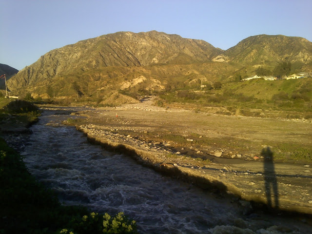
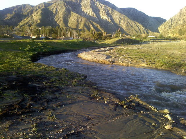
I went past the LZ Wednesday to assess the damage. I was hoping that they hadn't increased the flow from the dam. No such luck. This shot is from the bottom of the ramp. Too deep to wade with a harness and glider.

Image

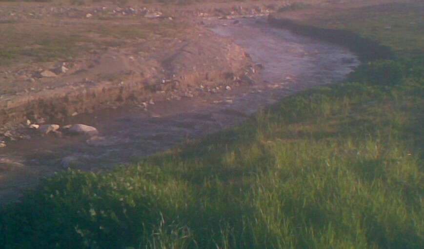
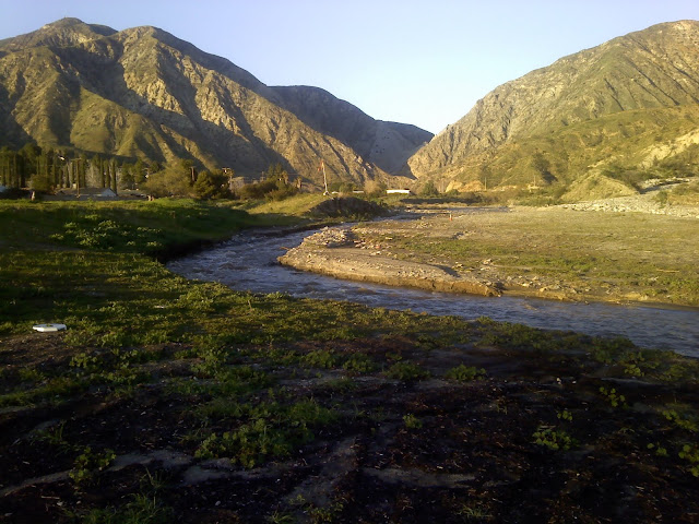
This second photo shows how the streambed changed from the East side to the West side of the wash. The white rocks at the center, right, are the bottom of the huge mud slide that changed the direction of the water.


Image

The H2-3 LZ is not in bad shape... you just can't get there from here.

Image

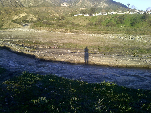
H4s: Do Not Land Short! Looking South from the bottom of the ramp.

Image

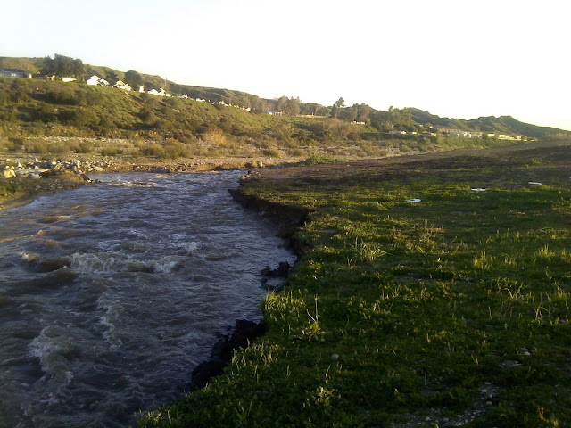
A bit farther to the North and you can see that the flow has completely moved to the West bank of the wash. The water will have to be turned off before any repairs can be made. Unfortunately, the LZ is now the low spot. Whatever happens, there is a lot of work to do. The BOD will probably be discussing repairs Thursday night.

Image
User avatar
noack
Posts: 58
Joined: Fri Feb 13, 2009 4:04 pm

Post by noack »

Thanx for the update Jim.

Does anybody know what this means for us H-2's that want to fly this weekend???????

Matt
User avatar
Don
Posts: 512
Joined: Thu May 12, 2005 8:58 am

Can You Swim???

Post by Don »

The weather for this weekend (wind direction) does not look promising for Kagel.
User avatar
dhmartens
Posts: 938
Joined: Sun Dec 03, 2006 11:36 am
Location: Reseda

Post by dhmartens »

It looks like we might have gotten back our old 2002?-2004? landing field to the east of the stream. If true then all's we need is a portable bridge
Image

Image

Image
greblo
Posts: 464
Joined: Wed Jan 18, 2006 11:22 am

Post by greblo »

Looks like Northerly winds will blow out Kagel all weekend. I'm out of town until next week so I won't be able to help those not signed off to fly anywhere but Kagel.

Joe
Safety is a book, not a word
Michael Robertson
knumbknuts
Posts: 33
Joined: Sun Dec 16, 2007 10:36 pm

Post by knumbknuts »

Yo slymartian brothers and sisters,

I've got some 'sperience from cutting via testes about bridges, culverts, and diverting waterways... and ours was a non-blue-line ravine, whereas you're dealing with a flat out river.

If you muck around in the wash much with Joe's skip loader or build a bridge or do anything significant, keep an eye on this webpage.

http://www.dfg.ca.gov/habcon/1600/forms.html

We had to fill out the Lake or Streambed Alteration Notification Form. The Notification Process and Instructions give you the information on fees to pay (yours would likely be the minimum $224) and where to send the form and check.

Knumb-from-filling-out-forms-Knuts
User avatar
dhmartens
Posts: 938
Joined: Sun Dec 03, 2006 11:36 am
Location: Reseda

Post by dhmartens »

Schwarzenegger visits La Canada

http://www.lacanadaonline.com/articles/ ... ger211.txt

“I call on the federal government to take responsibility to help our residents pay for cleaning up the mud. Not only from the last two days, the mud that was flowing two weeks ago, the mud that is going to continue for the next three to five years,� Olhasso said. “This isn’t a one-time shot. The federal government must take responsibility for the mud that is coming out of their hills.�

http://www.sgvtribune.com/news/ci_14352520

Assemblymember Anthony Portantino says:
"Portatnino applauded the community for coming together, neighbors lending shovels to neighbors."

Sounds to me like the Assemblyman wants a workparty.
User avatar
dhmartens
Posts: 938
Joined: Sun Dec 03, 2006 11:36 am
Location: Reseda

Post by dhmartens »

JT, Tony and I were out today. Wading across, the river snatched a velcro sandal right off my foot and I watched it float away to oblivion. Tony waded across much farther up but found himself neck deep. Danny is seen landing here and the second pic shows the water level dropping at about 4:30pm Saturday after the completion of a small leaking-like-a-sieve dam redirected water back to the original channel.
Image
Image
JT

Post by JT »

Doug, you weren't kidding about those tiger fish; good thing it didn't get your foot when it went for your sandal.

Anyone coming out tomorrow? Bring a shovel and gloves. If you have nothing better to do on Valentine's Day or Pres' Day, go over to the break in the berm and start tossing more rocks in. Or dig a trench through the sand at the base of the mud flow to start a diversion of the water to a new channel. Doug started a little one today and all the brush, logs, a homeless person's mattress and tarp and all the rocks we pitched into the creek above the breach raised the water level enough that it may be possible to get it going back down the East side. The large water flow will help cut this channel if it gets going. The more people out there, the better the chance we can put enough rock and junk in the main flow that we can divert this, get the water out of the LZ and get started on repairs at the ramp. Greblo will not be able to do anything in the wash if the water continues to flow down the West bank.

It would be best to cross to the East side of the water to get to the mud flow from Santiago; there are lots of rocks of all sizes to toss into the gap. The West side is depleted. I recommend using the Gavina bridge to cross unless you want to get really wet. Tony DeSantis crossed above my beaver dam and found the water was around 5 feet deep in the center of the stream.
It will take a huge number of rocks but it can be done. Tossing in branches broken off from burned trees and brush nearby helps, too. If anyone has sand bags to fill, that would be great to finish the dam. I may be back but I'm pretty beat tonight after more than 3 hours of heaving stuff into the water. Tony's been out for hours, two days in a row.
User avatar
Steve90266
Posts: 488
Joined: Fri Nov 30, 2007 6:05 pm
Location: Manhattan Beach
Contact:

Washed out LZ

Post by Steve90266 »

If we stocked this thing with rainbow trout and do some fly fishing! We'd have to get rid of the piranha first.
Steve Murillo
User avatar
dhmartens
Posts: 938
Joined: Sun Dec 03, 2006 11:36 am
Location: Reseda

Post by dhmartens »

The good news is as of Sunday 80% of the river had gone back into its original channel, like relocating a dislocated shoulder. We patched about 1/3 of the leaks but that put a strain on the south most patch because the main channel was still blocked with some sand flow that should be washed down stream by now. Any future repair work should keep an eye on that narrowing of the channel. Max and GQ Model Tom Casper were out in force on the channel repair. JT worked on the original berm breach repair and was aided by Chip and clan when Jeff Carlisle brought some advanced technology engineering to the task. While that patch almost worked it succumbed to the over whelming forces of nature. The smaller the breach, the higher the velocity. A 5 gallon per minute sand canal wasn't enough to take over.

Even with the new channel the way it is now it could be flyable, with a few wide stepping stones to cross, and smoothing down of the deep erosion cliffs. It could be a nice scenic addition.

Anyway turns out one of the piranhas got my leg while I was wading in shorts, long pants are recommended.

Oscar posted a video of the new channel under amazing flights "Todays landings 2-15-10"
Doug
User avatar
dhmartens
Posts: 938
Joined: Sun Dec 03, 2006 11:36 am
Location: Reseda

Post by dhmartens »

Despite nearly losing the skip when the dam opened up while she was stuck mid channel, the main channel is repaired ala JT's initial vision. Tom Casper, Joe Greblo and my self were out today. Once the water found its way back to the original channel by Tom and me lifting a few rocks, the 6 foot breach was easily repaired. The inch and a half rain we just got ducted itself to the south on the mud fan so unless we get another 4" burst, we should be breach free. I wonder if Kagel will be launchable by 1pm tomorrow.
Post Reply