dhmartens wrote:I liked that show on CBS, Survivor, where they do those puzzles and obstacle courses. Maybe launch Kagel, top land 1500, get puzzle pieces and a key. Relaunch and top land Trash, open a box with the key and get more puzzle pieces. Relaunch and land the LZ. Run to a table, dump out your puzzle pieces and solve the puzzle.
Jim,
as You know I have been listening to Ron for 9 years as a non pilot, and 1 year as a pilot talk about these places and I have an idea where they are. Could I show you them on a map? No.
I only know west towers since its an obvious one. I have yet to be released on my own so I have not had the chance to explore any loation other then the volcano...
On another note, I got my vario in and now have my PDA based flight computer working. I just need ot pick up the mount from Joe and make an interface plate and then I am good to go.
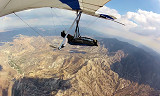
If we had a X marks the spot video of these places as you fly over them would be helpful ,everything looks so different from the ground.Jonathan could make one He seems to fly the whole range regularly with his HD camera.what do you think NME,could you help us out.
Even GPS coords of each location would work and we could go on google earth and see them. However a video would be best. I still have problems seeing the Volcano from above at times..
If someone wants to bring a laptop to the LZ with Google Earth loaded, that is a good introduction. Many of the commonly used waypoints are also visible from the LZ. Many more can be seen from launch. We can discuss why they're named, what to find there and when to bail.
If someone can print out a panoramic view of the range from Google Earth, we could make a map that could be used for reference when needed.
The best is to hope for some consistent 6K days when you all can get up enough altitude to tour around with me or another experienced pilot.
While we're waiting, we can get together anytime and talk about thermal etiquette - what's expected and right-of-way.
I only know west towers since its an obvious one. I have yet to be released on my own so I have not had the chance to explore any loation other then the volcano... .......
Marc
The idea of showing folks where the named spots are is a good one. They aren't always where you think. For example, usually when we go to West Towers, we don't go to the tower. That's deeper (farther N) than you want to go without extra altitude, especially on a windy day. There's another spot (a "T") farther S on the same finger.
But how are you gonna figure out where "Stacey's", "Stupid", etc. are without being shown? Their names sure don't tell you! Google Earth is great for that stuff.
Talking with a few pilots in the LZ today, we thought it would be a good idea to cruise the most often used alternative landing site, Big T. Next weekend, weather permitting, is anyone interested in arriving early and taking a side trip to the Big T wash? We may also go West and have a look at the field next to the Olive View hospital. Answer here and I'll set up a time and work out rides.
I'll be back in the air again in about a month or so. The jr falcon league is a great idea. Flying with in experienced pilot would help greatly in improving skills such as staying with a thermal which is something I am struggling with. Being guided by radio from someone flying in the same air as I would speed up learning and make it more fun as well.
Let's not let this idea die!
Drachenflieger wrote:............Flying with in experienced pilot would help greatly in improving skills such as staying with a thermal which is something I am struggling with. Being guided by radio from someone flying in the same air as I would speed up learning and make it more fun as well............
Future welcome back, Mike. Rob and Ron have been doing exactly this with Janyce and to a lesser extent, Matt. It's fun to do air-to-air coaching. I've done a limited amount myself. I'm sure some of us would be willing to play aerial coach for you and others. I'm willing to do it for imports or microbrews.