I was on top of Kagel this morning...lots of heli action going on. I ended up hiking down (for other reasons), but it got me thinking.
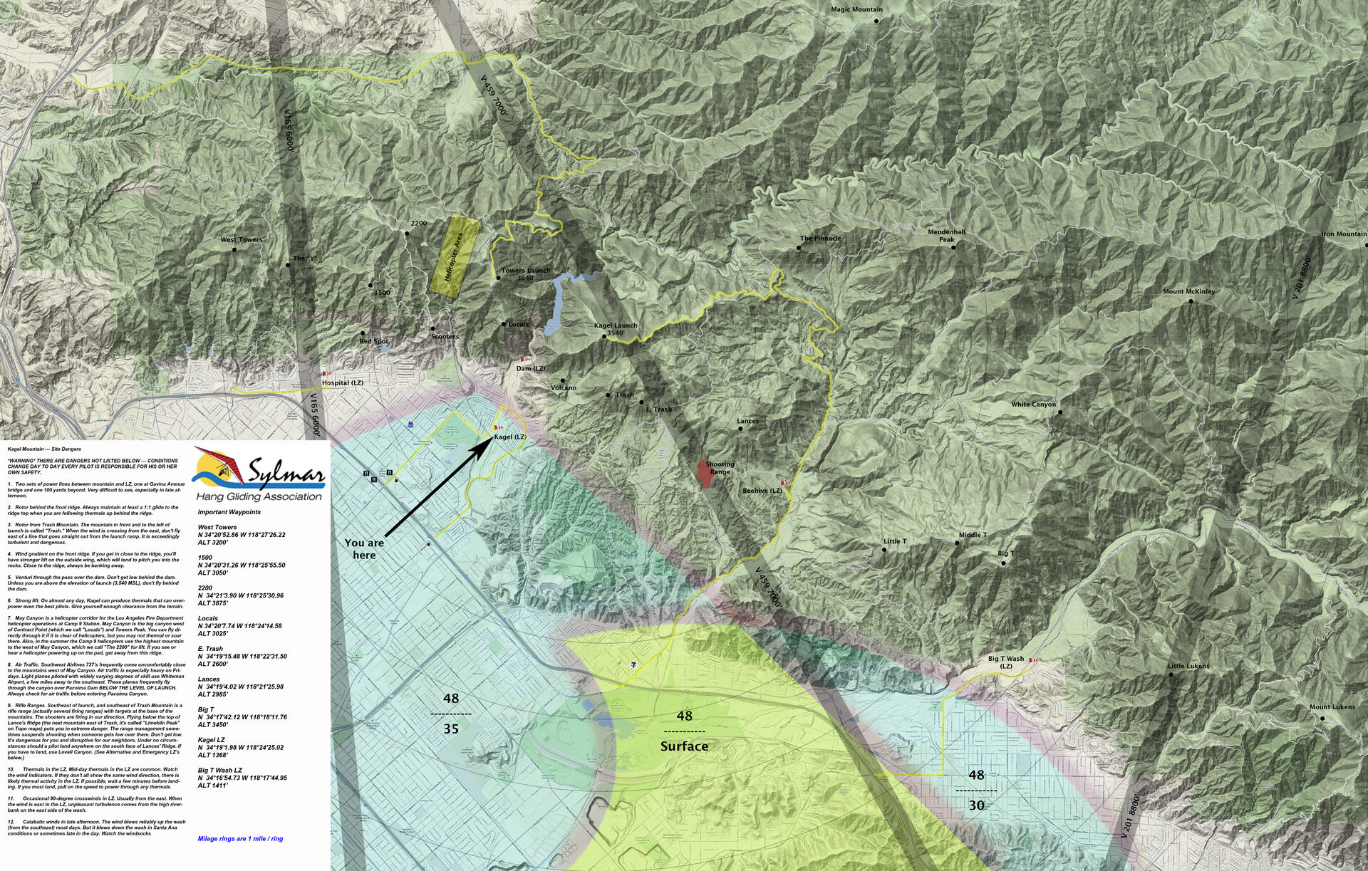
The club web site has a fairly vague description of the May Canyon Helicopter Corridor (which we are not to linger in). Is the vertical and lateral extent (or at least nominal altitude and centerline) actually defined and charted somewhere? It's not on the sectional, LA TAC, or LA Heli-west charts. If there is more detail available, I'd appreciate it. Of curse "see and avoid" always rules, but I just want to make sure that I am not unintentionally lingering where one should not.
Thanks,
Greg
May Canyon Heli Corridor?
Moderator: Chip
Hi Greg,
I'm guessing that you won't find this in federal documents because Fire Camp 9 is part of the County of Los Angeles Fire Department. I know there are rules for motor vehicles to pull over to the side before an emergency vehicle with sirens or flashers activated but how would we ever know with a Camp 9 chopper?
Here is where you can ask for specifics: http://www.fire.lacounty.gov/home/contact-us-2/
Just an FYI - Last Summer I had a close encounter with a Bell 205 heading back to Heap's Peak. Yes, it's on video. It took some searching but I finally got both the pilots and crewman on the telephone. This was a U.S. Forrest Service chopper heading back to refuel after scoping hot spots following blaze suppression near Oak Glen.
The bottom line is this: In spite of passing just 250' below me, neither crew member saw me. This was in spite of the fact that I was high above the ridge line over Running Springs and there was nothing to obscure their view of my glider. My wing has a very high contrast black and fluorescent color scheme designed to make me more visible for exactly this reason. Normally there is zero air traffic along this ridge save for the infrequent hang glider and even rarer PG. In spite of all this I was not seen as they were focused on getting back to base.
During our conversation the pilot in command did ask me to tell the rest of the Crestline club to stop lingering near Heap's Peak as it created a serious safety hazard. There are three chopper pads and they can come in to land at high speeds and be running low on fuel. Unpowered ultralights are anything but predictable. So my outreach served well to create goodwill and communication. Has this stopped pilots from lingering by Heap's Peak? I have no idea but I hope we maintain good relations and safety.
So please reach out to the LACFD and extend our spirit of cooperation: http://www.fire.lacounty.gov/home/contact-us-2/
I'm guessing that you won't find this in federal documents because Fire Camp 9 is part of the County of Los Angeles Fire Department. I know there are rules for motor vehicles to pull over to the side before an emergency vehicle with sirens or flashers activated but how would we ever know with a Camp 9 chopper?
Here is where you can ask for specifics: http://www.fire.lacounty.gov/home/contact-us-2/
Just an FYI - Last Summer I had a close encounter with a Bell 205 heading back to Heap's Peak. Yes, it's on video. It took some searching but I finally got both the pilots and crewman on the telephone. This was a U.S. Forrest Service chopper heading back to refuel after scoping hot spots following blaze suppression near Oak Glen.
The bottom line is this: In spite of passing just 250' below me, neither crew member saw me. This was in spite of the fact that I was high above the ridge line over Running Springs and there was nothing to obscure their view of my glider. My wing has a very high contrast black and fluorescent color scheme designed to make me more visible for exactly this reason. Normally there is zero air traffic along this ridge save for the infrequent hang glider and even rarer PG. In spite of all this I was not seen as they were focused on getting back to base.
During our conversation the pilot in command did ask me to tell the rest of the Crestline club to stop lingering near Heap's Peak as it created a serious safety hazard. There are three chopper pads and they can come in to land at high speeds and be running low on fuel. Unpowered ultralights are anything but predictable. So my outreach served well to create goodwill and communication. Has this stopped pilots from lingering by Heap's Peak? I have no idea but I hope we maintain good relations and safety.
So please reach out to the LACFD and extend our spirit of cooperation: http://www.fire.lacounty.gov/home/contact-us-2/

Yo, peep this: http://www.shga.com/images/forum/SylmarFinal.jpg
It's not charted. It's more of an agreement we have with the fire refueling base called LA County Fire Camp 9 or just "Camp 9" for short. I've never seen their firehawk helicopter more than 500' over their camp. It usually just squirts in and out. I was once 1000'+ above and watched it land and take off from the pad. The take off was the most interesting. It didn't hover vertically very high off the pad. It seems to just drip over the hillside and go on its way. I believe this kind of approach/depart saves fuel, time and is safer. All that said. The operators of that base know about us. They take conscientious paths in and out. They have even picked up one of us after a blown launch on Kagel.
I would be more worried about: GA aircraft flying fast and low over the dam. I'm not sure how much "seeing and avoiding" they are doing as they quickly approach Whiteman. Seems they would be busy doing landing checklists/radio work. I typically look both ways when crossing the street and crossing the dam. Also I'd be on the lookout for low 737s when near west towers. I'm sure it was an optical illusion, but once it appeared a Southwest jet was both below me and between me and launch. I'm sure neither of us could either see or avoid each other. The disparity of speed and size is too great. Just avoid flying high on the western half of the range.
It's not charted. It's more of an agreement we have with the fire refueling base called LA County Fire Camp 9 or just "Camp 9" for short. I've never seen their firehawk helicopter more than 500' over their camp. It usually just squirts in and out. I was once 1000'+ above and watched it land and take off from the pad. The take off was the most interesting. It didn't hover vertically very high off the pad. It seems to just drip over the hillside and go on its way. I believe this kind of approach/depart saves fuel, time and is safer. All that said. The operators of that base know about us. They take conscientious paths in and out. They have even picked up one of us after a blown launch on Kagel.
I would be more worried about: GA aircraft flying fast and low over the dam. I'm not sure how much "seeing and avoiding" they are doing as they quickly approach Whiteman. Seems they would be busy doing landing checklists/radio work. I typically look both ways when crossing the street and crossing the dam. Also I'd be on the lookout for low 737s when near west towers. I'm sure it was an optical illusion, but once it appeared a Southwest jet was both below me and between me and launch. I'm sure neither of us could either see or avoid each other. The disparity of speed and size is too great. Just avoid flying high on the western half of the range.
Thanks for all of the information! That spells it out pretty well. Nice to have the graphic on my computer to study.
As for the heli takeoff...no need to hover. Hovering close to the ground is more dangerous. If something goes wrong you need to gain forward speed to autorotate. When hovering, you can also drop into your own rotorwash...also no good. So as soon as they are clear of the ground they want forward speed. Safe and efficient.
I am also an (inactive) airplane pilot, so I understand a bit from their perspective. Yes, one can be pretty busy when on approach. However, that is absolutely the most important time to have your head on a swivel as airports have a way of attracting converging aircraft (funny, that). However, the reference the "site dangers" description of "vary degrees of skill" is spot on.
I will look both ways before crossing the canyon and keep my head on a swivel!
As for the heli takeoff...no need to hover. Hovering close to the ground is more dangerous. If something goes wrong you need to gain forward speed to autorotate. When hovering, you can also drop into your own rotorwash...also no good. So as soon as they are clear of the ground they want forward speed. Safe and efficient.
I am also an (inactive) airplane pilot, so I understand a bit from their perspective. Yes, one can be pretty busy when on approach. However, that is absolutely the most important time to have your head on a swivel as airports have a way of attracting converging aircraft (funny, that). However, the reference the "site dangers" description of "vary degrees of skill" is spot on.
I will look both ways before crossing the canyon and keep my head on a swivel!