Last Revised: May 9, 2025
Overview
Sylmar is the world capital of hang gliding and pilots have been flying hang gliders in these mountains since 1969. The first U.S. National Hang Gliding Championships were held here in 1973.
The Flight Park is located just outside of Los Angeles and we enjoy around 300 days of flying a year. Please read the complete site briefing below before flying here.
Pilots and non-pilots are welcome to enjoy our flight park year ’round! Fly high, fly far, fly safe!
Details
Membership & Proficiency Requirements
What is required of a pilot to fly at Kagel?
- Current USHPA membership (card must be carried by the pilot).
- Current SHGA membership (join here).
- Understanding and demonstration of SHGA Rules, Guidelines, Site Dangers, and landing pattern.
- Hang/para glider pilots must be rated H/P-3 (Intermediate) or higher.
- H-2 (Novice) hang glider pilots and P-2 (Novice) paraglider pilots may fly if under the direct supervision of an instructor.
- H-2 (Novice) hang glider pilots and P-2 (Novice) paraglider pilots may fly with a sign-off from a local SHGA designated instructor if they receive a site briefing each day they fly from an Intermediate or higher rated pilot on the days conditions.
- PROOF OF SIGN-OFF MUST BE CARRIED BY THE PILOT.
Can I fly at Kagel if I’m not a SHGA member?
No, but we offer a $10 monthly membership. Visiting pilots must also meet the requirements listed above.
Kagel Launch (HG Main Launch)
The Kagel Main launch is on the left (east) side of the launch area, at the top of the ridge, facing south. It is a H3 Launch, PG launch is not recommended.
- Elevation and glide: 3537 feet MSL, 4.1:1 glide ratio to LZ.
- Ideal wind direction: SE to SW, 150 to 220 degrees.
- Launchable wind direction: SE to SW, 120 to 240 degrees.
- Wind velocity:
- HG: Ideal is 5 MPH. Suggested min 0 MPH to max 20 MPH, Gust factor 10 MPH.
- PG: Ideal is 5 MPH. Suggested min 0 MPH to max 15 MPH, Gust Factor 5 MPH.
- HG: Ideal is 5 MPH. Suggested min 0 MPH to max 20 MPH, Gust factor 10 MPH.
- Glide Ratio required to LZ: 4.1
Other Notes
- Steep slope launch presents difficulty (suck) in high winds.
- Pointiness/asymmetry of the Kagel main launch presents difficulty (wing-imbalance) in turbulent and shifting winds.
- West winds create a potential rotor hazard
Saddle Launch (PG Main Launch)
The Kagel Saddle launch is on the right (west) side of the launch area, in the saddle below main launch. It is a H4 Launch, and is the main PG launch area, a P3 launch. For hang glider pilots, the saddle launch is deceptive, due to the very low ground clearance for both wingtips and shallow slope. Please exercise care when using it, and keep wings level through the launch run. Do not launch the saddle when the wind is cross, due to rotor off of the main launch or the ridge to the right.
- Elevation and glide: 3530 feet MSL, 4.1:1 glide ratio to LZ.
- Ideal wind direction: Due S, 180 degrees.
- Launchable wind direction: SE to SW, 170 to 190 degrees.
- Wind velocity:
- HG: Ideal is 5 MPH. Suggested min 0 MPH to max 20 MPH, Gust factor 5 MPH.
- PG: Ideal is 5 MPH. Suggested min 0 MPH to max 15MPH, Gust Factor 5MPH.
- HG: Ideal is 5 MPH. Suggested min 0 MPH to max 20 MPH, Gust factor 5 MPH.
- Glide Ratio required to LZ: 4.1
Other Notes
- Saddle shape of the launch and flat slope present dangers in low and cross winds and turbulence. Foliage growth increases the dangers.
Getting to Launch
How do I get to launch?
Kagel Mountain is located in the Angeles National Forest. The road to launch is a gated unimproved fire road off Little Tujunga Canyon Road. Visiting pilots must contact a current SHGA member for access to the road. A four-wheel drive vehicle is recommended. Most pilots meet in the Flight Park (landing zone) and carpool to launch.
SHGA Club Rules
Club Rules
- Requirements – Pilots must be SHGA members possessing an Intermediate (H3 or P3) rating. Novice rated pilots may be sponsored to fly here with additional instruction outlined here. Visiting pilots may obtain a monthly membership for $10.
- Safety Equipment – All pilots must wear a helmet and emergency reserve parachute.
- Flight Rules – All flights must be in accordance with FAR Part 103, particularly the rules concerning hazardous operation (FAR 103.9), flying near other aircraft, vigilance and collision avoidance (FAR 103.13), visual contact with the ground (FAR 103.21) and proper clearance from clouds (FAR 103.23).
- Restricted Areas – Flying is PROHIBITED:
a. In Burbank Class C Airspace (south of Gavina Avenue, between 3,000 and 4,800 MSL),
b. In the Whiteman Airport Class D Airspace,
c. In the Heliport Corridor in May Canyon, except for a direct transit, without soaring,
d. Over the houses west of Pacoima wash, or within 200 feet horizontally of those houses, and
e. Over the baseball fields south of the LZ during games or gatherings of people. - Helicopter Operations – Flying is prohibited within three miles of a helicopter rescue or aerial fire fighting operation. During a rescue or fire fighting operation within three miles of the Sylmar LZ (east to Little Tujunga Canyon Road and west to Wilson Canyon just short of West Towers) , no further launches are permitted, and all pilots must immediately clear the area in a way that minimizes conflict. Depending on the situation, pilots may choose to land immediately in the Sylmar LZ or in an alternate LZ, or leave the area with the expectation of landing elsewhere.
- Kagel Mountain Launch – (Saddle and Main Ramp) Intermediate or higher rating is required. There are specific requirements for visiting novice (H2 and P2) pilots. Please review the site guide on this page.
- All Launch Sites Within 5 miles of Kagel Mountain – Advanced rating is required. Intermediate pilots may fly under the direct supervision of, or if signed off by an SHGA-designated instructor. Proof of sign-off must be carried by the pilot. Sign-off may be revoked at the discretion of the Association.
- SHGA Flight Park Landing Area – No part of any landing approach may cross the 200-foot buffer zone markers.
- Tandem Flights – Pilots and passengers must have the appropriate USHPA ratings. The pilot is responsible for ensuring that the passenger has signed the USHPA form Assumption of Risk and Liability Waiver. Prior to a recreational tandem flight, the pilot and passenger must sign SHGA’s Non-Commercial Tandem or Instruction Acknowledgement in the LZ.
- Aerobatics – Aerobatics are spins and maneuvers that involve bank angles greater than 90 degrees from horizontal or pitch angles greater than 60 degrees. No aerobatics are permitted south of the Gavina Avenue bridge. All aerobatic maneuvers must be performed in clear airspace, at a safe distance from other aircraft, and must be completed no less than 750 feet above ground level.
- Powered Ultralights – No SHGA member may fly an ultralight with a motor onboard south of the ridgeline between the radio antennas at West Towers and the Little Tujunga Road, whether or not the motor is operating. Powered harnesses fall within the scope of this rule. An ultralight with neither a fuel tank nor a propeller is exempt from this rule.
- Dogs – Any dog on SHGA property must be under the direct supervision of its owner and under control. No dog may be left alone in the LZ unsupervised. No dog may be left to the supervision of anyone else. The owner must be present, or the dog must be placed in a secure, safe, enclosed space, such that they are not able to wander, cause accidental harm to persons, other animals, or damage to property. Any dog that creates an annoyance, in the judgement of the board, may be excluded from the property.
Right of Way Rules
- Hang gliders and paragliders (unpowered ultralight vehicles) must yield right of way to all other aircraft except powered ultralights. This is the law (FAA Federal Aviation Regulations Part 103).
- As you approach another aircraft head on, you should steer to your right of the approaching aircraft. (Like a car on the road.)
- When thermalling, the first pilot to enter a thermal establishes the required turning direction in that thermal.
- When ridge soaring, the glider closest to the ridge has right of way.
- The lower aircraft has the right of way.
- When ridge soaring, a glider overtaking another glider that is flying in the same direction should pass between the ridge and the glider being overtaken.
R/C Guidelines
- The operator must be an SHGA member in good standing.
- R/C flying shall only be permitted from 9 AM to sunset.
- The operation of R/C aircraft shall not be conducted if any hang glider or paraglider is within a one-quarter mile radius of the landing zone and less than 500 feet AGL.
- R/C Pilots shall monitor noise levels of their motors so as not to disturb the neighbors.
- All R/C flights should be south of the “Overshoot” Ramp.
- Launching and landing should be done as far south and east in the LZ as is possible, consistent with safety.
- Under no circumstances, should you fly any R/C near the houses on the West side of the LZ.
- No internal combustion engines on R/Cs at all.
- If your fellow R/C pilots are flying outside of these guidelines, please remind them that you really don’t want new rules, or an R/C ban, and you would appreciate it if they followed the guidelines.
- No R/C operations during an active TFR.
Landing Information
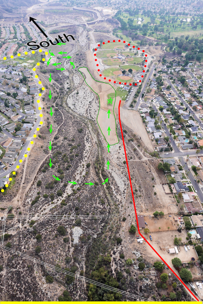
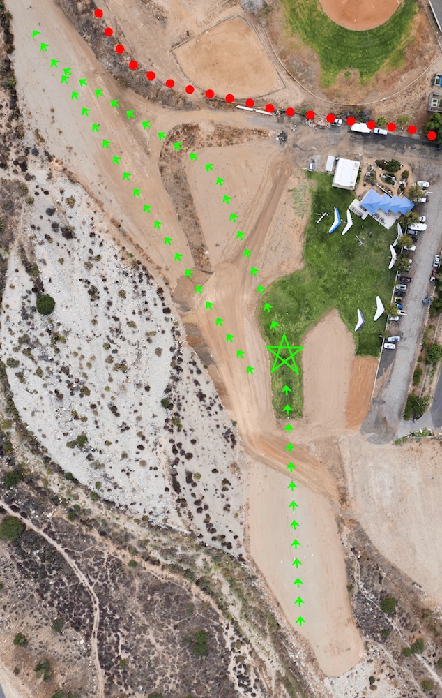
These aerial photographs show the Sylmar Flight Park and surrounding areas, looking south.
The landing zones are outlined in green, with the “target” shown as a pentagram at the center of the grass runway for ALL PILOTS. Overshoot areas shown as small green arrows beyond the pentagram target and into the wash on the left. Please do not land in the baseball field parking lot. The landing pattern should be a left-hand “aircraft” type approach as shown by the large green arrows.
No part of any landing approach may cross to the west (right) of the 200-foot line, shown as a solid red line, and marked with traffic cones on the field. “S” turns are discouraged, as they may lead to a loss of control and could cause conflicts with others in the landing pattern. The dotted red area is the Sylmar Independent Baseball League (SIBL), and one must not fly over this area when games are in session, nor land there, if the target LZ is missed.
The solid yellow line at the bottom of the larger area picture is the Gavina St. bridge (just out of the picture). Pilots must be less than 3,000 ft. MSL before crossing this street and proceeding to the landing zone. The subdivision marked by the dotted yellow area is Santiago Estates; pilots may fly over these homes. Note that there are two sets of power lines between Gavina Street and the LZ highlighted in orange these may an issue if coming in low.
Paragliders may kite in the LZ runway, but must stop kiting and rosette wings when any pilot begins a landing approach by crossing the bridge.
Flying over any other residential areas is strictly prohibited.
Site Dangers
*WARNING* THERE ARE DANGERS NOT LISTED BELOW — CONDITIONS CHANGE DAY TO DAY. EVERY PILOT IS RESPONSIBLE FOR HIS OR HER OWN SAFETY.
- Deceptively dangerous Kagel Saddle Launch. Reduced ground clearance at hang glider wing tips. Shallow slope launch. Rotor in cross winds. Don’t use this launch when wind is gusty, light, or cross.
- Two sets of power lines between mountain and LZ, one at Gavina Avenue bridge and one 100 yards beyond. Very difficult to see, especially in late afternoon.
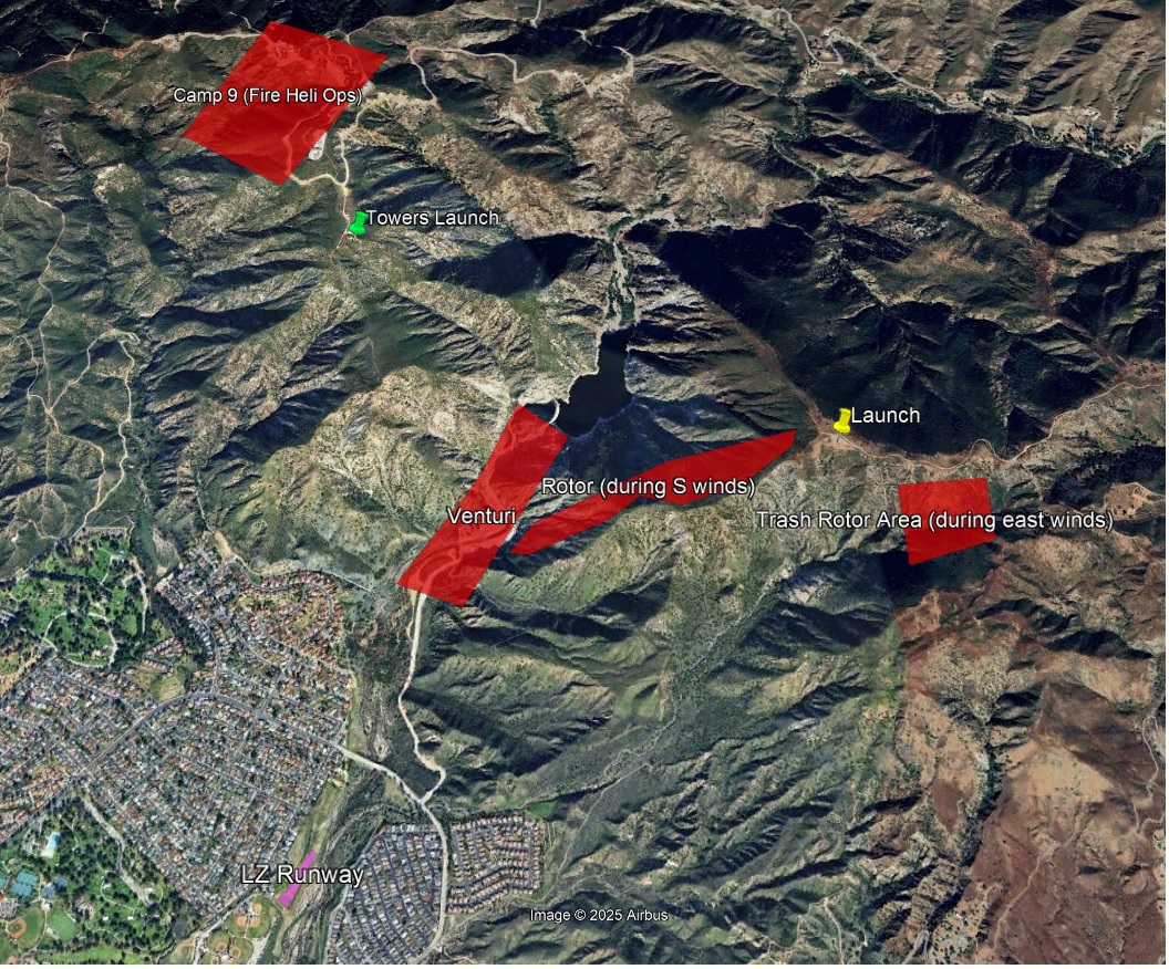
- Rotor behind the front ridge. Always maintain at least a 1:1 glide to the ridge top when you are following thermals up behind the ridge.
- Rotor from Trash Mountain. The mountain in front and to the left of launch is called “Trash.” When the wind is crossing from the east, don’t fly east of a line that goes straight out from the launch ramp. It is exceedingly turbulent and dangerous.
- Wind gradient on the front ridge. If you get in close to the ridge, you’ll have stronger lift on the outside wing, which will tend to pitch you into the rocks. Close to the ridge, always be banking away.
- Venturi through the pass over the dam. Don’t get low behind the dam. Unless you are above the elevation of launch (3,540 MSL), don’t fly behind the dam.
- Strong lift. On almost any day, Kagel can produce thermals that can overpower even the best pilots. Give yourself enough clearance from the terrain.
- Restricted airspace. May Canyon is a helicopter corridor for the Los Angeles Fire Department helicopter operations at Camp 9 Station. May Canyon is the big canyon west of Contract Point (which we call “Locals”) and Towers Peak. You can fly directly through it if it is clear of helicopters, but you may not thermal or soar there. Also, in the summer the Camp 9 helicopters use the highest mountain to the west of May Canyon, which we call “The 2200” for lift. If you see or hear a helicopter powering up on the pad, get away from this ridge.
- Air Traffic. Southwest Airlines 737’s frequently come uncomfortably close to the mountains west of May Canyon. Air traffic is especially heavy on Fridays. Light planes piloted with widely varying degrees of skill use Whiteman Airport, a few miles away to the southeast. These planes frequently fly through the canyon over Pacoima Dam BELOW THE LEVEL OF LAUNCH. Always check for air traffic before entering Pacoima Canyon.
- Clouds obscure visibility and create the hazard of collision with other aircraft. Stay away from clouds.
- Rifle Ranges. Southeast of launch, and southeast of Trash Mountain is a rifle range (actually several firing ranges) with targets at the base of the mountains. The shooters are firing in our direction. Flying below the top of Lance’s Ridge (the next mountain east of Trash, it’s called “Limekiln Peak” on Topo maps) puts you in extreme danger. The range management sometimes suspends shooting when someone gets low over there. Don’t get low. It’s dangerous for you and disruptive for our neighbors. Under no circumstances should a pilot land anywhere on the south face of Lances’ Ridge. If you have to land, use Lovell Canyon. (See Alternative and Emergency LZ’s below.)
- Thermals in the LZ. Mid-day thermals in the LZ are common. Watch the wind indicators. If they don’t all show the same wind direction, there is likely thermal activity in the LZ. If possible, wait a few minutes before landing. If you must land, pull on the speed to power through any thermals.
- Occasional 90-degree crosswinds in LZ. Usually from the east. When the wind is east in the LZ, unpleasant turbulence comes from the high riverbank on the east side of the wash.
- Catabatic winds in late afternoon. The wind blows reliably up the wash (from the southeast) most days. But it blows down the wash in Santa Ana conditions or sometimes late in the day. Watch the windsocks.LZ maintenance should not be performed during the day, but may occur. LZ maintenance should only be performed if a spotter is present to notify any workers of incoming landings. Pilots should be given right of way but all pilots should be prepared to land in the overshoot if maintenance equipment (notably the skiploader) is present in the primary LZ.
Visiting Pilots
Novice (H2 and P2) Pilots
Occasionally visiting Novice pilots from other areas desire to fly at this site prior to earning the USHPA Intermediate rating. Since this park can be flown very inexpensively by Intermediate Rated pilots, it may make sense for pilots to wait until they acquire their Intermediate rating before they come to fly here. Some novice pilots believe that they can be evaluated and sponsored to fly this site with only 1 flight orientation lesson. Although this is possible, it is rarely the case. Due to the more complex nature of the site and the landing area, visiting Novice pilots wishing to fly this site will usually require several flight lessons (solo and/or dual), concentrating on modern Intermediate Level flight and approach skills, and specific site dangers. Each of these flight lessons require a fee paid to the flight school or instructor. With consistent well performed landing approaches into the landing strip, and the demonstration of some pertinent hang 3 skills, the Novice pilot can be sponsored to fly here without instruction. As a guide, it is common for Novice pilots in the Windsports training program to demonstrate the required skills in 6-8 mountain flight lessons. This allows them to graduate into the limited supervised program. It can be expected that visiting novice pilots with mountain training experience, cross wind launches and landings, and aircraft landing pattern skills can earn their sponsorship privileges in significantly fewer lessons. The following is a list of the pre-requisites and skills that need to be witnessed by the instructor during flight training before an instructor sponsorship can occur:
- USHPA Novice Rating
- Evaluation of launch and landing techniques at Dockweiler Beach (at the option of the instructor)
- SHGA membership
- Site orientation
- Demonstrated Launches with fully upright body, hands low on downtubes, consistent safe airspeed and holding a precise heading of +- 3 degrees. Prone to upright body and hand transfers while maintaining a heading +- 3 degrees
- Dives in the upright landing configuration (to 35 mph airspeed)
- Parachute deployment procedures (static simulated demonstration)
- Turning flight at Minimum Controllable Airspeed (mushing flight)
- Stall development in level flight
- Linked S – Turns to precise headings at 25 mph and 30 mph
- Efficient Minimum Sink Coordinated 360’s at 20, 30, 45 degrees bank angles
- Effective Aircraft Approaches in lift, sink, and light turbulence (These are to be performed fully upright with hands low on the downtubes and at approach speeds dictated by flight conditions)
- Performance airspeeds (speed to fly demonstrations in lift, sink, headwinds, tailwinds)
- Surface wind evaluation from in-flight observations without using windsocks or streamers
- Flight in light to moderate turbulence
- Orientation to flight park dangers
- FAA FAR 103 and Sectional Chart Exam
Towers Launch
On the west side of the Pacoima Reservoir is Contractor’s Point, known locally as Towers. This H4 launch is primarily used when access to Kagel Mountain is restricted. The launch is so steep that it is essentially a cliff, and while it faces ESE, a south wind will wrap around enough to be launchable. A westerly component to the wind makes this site unlaunchable, and that can be difficult to detect when standing on launch, and so one must check the wind direction from a more exposed location.
- Elevation and glide: 3640 feet MSL, 4.0:1 glide ratio to LZ.
- Ideal wind direction: SE, 135 degrees.
- Launchable wind direction: E to S, 90 to 180 degrees.
- Wind velocity: Ideal is 8 MPH. Suggested min 0 MPH to max 15 MPH, Gust factor 5 MPH.
- Glide Ratio required to LZ: 4.5
Other Notes
- Very steep launch.
- Hazardous footing due to eroding launch path/steepness.
- Hazardous vegetation obstacles when not regularly maintained.
- Hazardous in more than light winds; limited wire assistance available.
- West wind presents a rotor hazard. No setup tie-downs.
- Limited setup area.
- Few or no wind indicators.
Kagel North Launch (Backside Launch)
While not used frequently, it is possible to launch the back side in north winds. It is a H4 and P4 Launch. There are NO good LZs on the back side, so one must make it over or around the main ridge to the primary LZ. Experience has shown that if there is any significant westerly component to the wind, there is potentially dangerous turbulence and tremendous sink in front of launch and through the pass over the Pacoima reservoir. Be aware that with a north wind, when crossing the ridge to go to the LZ, rotor off the main ridge is very common.
- Elevation and glide: 3530 feet MSL, 4.8:1 glide ratio to LZ by the time one goes around the ridge.
- Ideal wind direction: N, 350 to 10 degrees.
- Launchable wind direction: N, 350 to 30 degrees.
- Wind velocity:
- HG: Ideal is 5 MPH. Suggested min 0 MPH to max 10 MPH, Gust factor 5 MPH.
- PG: Ideal is 5 MPH. Suggested min 2 MPH to max 10 MPH, Gust Factor 5MPH.
- HG: Ideal is 5 MPH. Suggested min 0 MPH to max 10 MPH, Gust factor 5 MPH.
- Glide Ratio required to LZ: 4.1*
- Note: Because you must circle the ridge or climb above it to get back to the LZ, this glide ratio may not be sufficient in all conditions.
Other Notes
- Flat slope and rotor from distant mountains present danger. Foliage growth increases the dangers.
Airspace
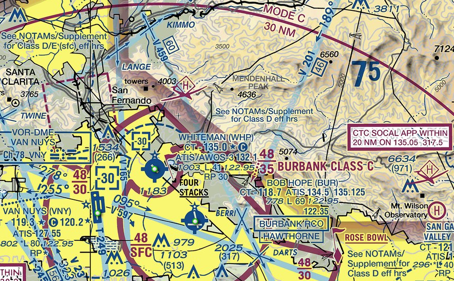
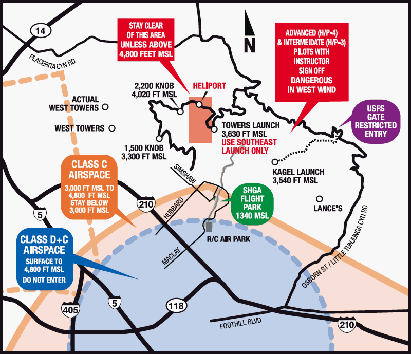
Airspace around the Sylmar Flight Park is complex. To avoid Class C and D airspace, pilots must be below 3,000 feet MSL (or above 4,800 feet MSL) when crossing south of the Gavina Street bridge, and should not cross south of the Harding Street bridge. There is also Class E surface airspace to the west of West Towers. SHGA has an agreement with the firefighters at the Camp 9 heliport that our pilots will not linger in their vicinity.
Emergency & Bailout LZs
For many reasons, landing at any one of these LZs is more dangerous than returning home at a comfortable altitude to the SHGA flight park. In addition to being unfamiliar, most are relatively small, surrounded by obstacles, and require cross-wind landings. For those who choose a flying style that involves a perceptible risk of landing out, it is valuable to walk these LZs and understand their complexities from the ground. Open land near Sylmar is in high demand and and is likely to be put to use, so it is best to visit these areas regularly. In short: stupid hurts.
These LZs are not maintained by the club and should only be considered for emergency use. The full list can be found here. Suggestions and updates are welcome.
Additional Info
- Site Frequency: 147.580 MHz.
- Emergencies: Follow the instructions and information available in the Emergency Action Plan.
- Rides: Need a ride to launch?
Kagel Launch Layout

LZ Layout
